Dear Residents,

We wish to notify you that the new 2024 Flood Insurance Rate Maps (FIRM) took effect on February 8, 2024, following several years of comprehensive study. These updated maps introduce changes that may have implications, some of which could be significant, for our residents.

As a result of the updates, some property owners may now be required to purchase flood insurance, even if they were not previously obligated to do so. We understand that this may raise questions or concerns, and we are here to assist you through this transition.

Our team is dedicated to supporting you throughout this process and addressing any questions or concerns you may have regarding the changes to the flood maps. The City of Naples Building Department will be hosting two informal open houses for the public on Thursday, February 29th; one in the morning and one in the evening. Please stay connected with us for further details regarding the open houses.

Sincerely,

Jay Boodheshwar

City Manager

2024 FEMA FLOOD MAPS

Effective February 8, 2024

To gain insight into the changes within the 2024 FEMA Flood Maps and determine if your property is affected, please follow these steps:

  1. Click the link provided below to access the City’s Forerunner website.
  2. Enter your property address to access your property’s flood information.
  3. Note that the “Effective FIRM” refers to the 2024 FEMA Maps, while the “2012 Historic FIRM” pertains to the 2012 FEMA Maps. Although the 2012 maps are not the current standard, residents have the option to utilize them if building to the higher of the two elevations, whichever map indicates the higher elevation.
CITY OF NAPLES’ FLOOD INFORMATION WEBSITE

Understanding the Newly Mapped Procedure

What is changing?

A property’s flood risk may be changing from a moderate- to low-risk flood area (Zone B, C, or X) or Unknown (Zone D) to a high-risk area (Zone A or V).Text Link

What this means for residents:

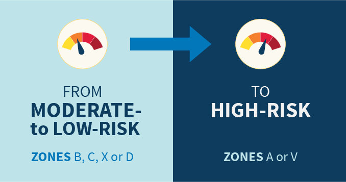
For residents that are newly identified to be a high-risk flood area, the National Flood Insurance Program (NFIP) offers a cost-saving option called the Newly Mapped Procedure.

With NFIP’s pricing approach, Risk Rating 2.0, Newly Mapped discounts and subsequent rate increases continue. Premiums will continue increasing gradually and within the existing statutory limits set by Congress until reaching the full risk premium. 

If the building is sold, the policy can be transferred to the new owners, allowing them to keep the lower-cost rate. Clients must maintain coverage continuously to keep their Newly Mapped rate.

NFIP’s Pricing Approach

With NFIP’s pricing approach, FEMA now has the capability and tools to address rating disparities by incorporating more flood risk variables like flood frequency, multiple flood types — river overflow, storm surge, coastal erosion, and heavy rainfall — and distance to a water source, as well as property characteristics such as elevation and the cost to rebuild. 

This means that although flood mapping data will still be necessary and essential for communities, and Flood Insurance Rate Maps (FIRMs) will continue to be used for mandatory purchase requirements, building code requirements, and floodplain management requirements, flood maps will no longer be the most significant factor in rating premiums.

Newly Mapped (A Property Newly Mapped into the SFHA)

According to FEMA.gov, a property that was once designated outside of the Special Flood Hazard Area (SFHA) on an effective Flood Insurance Rate Map (FIRM), and following a map revision, is designated within the SFHA. Property newly mapped into the SFHA by a map revision on or after April 1, 2015, and meeting certain loss history requirements is eligible for the Newly Mapped rating procedure outlined in the Newly Mapped section of this manual if coverage is purchased within 1 year of the map revision and continuously maintained. A property meeting the loss history requirements and newly mapped into the SFHA by a map revision effective on or after October 1, 2008, and before April 1, 2015, may be insured under the Newly Mapped rating procedure if coverage is purchased on or after April 1, 2015, but before April 1, 2016, and maintained continuously. The newly mapped procedure is not available for any property mapped into the SFHA by the initial FIRM.

Know Your Flood Risk: Homeowners, Renters or Business Owners

Flooding remains the country’s number one disaster and can potentially affect everyone and every property.  

Click the button below for FEMA’s guide to help people to understand and navigate flood risk and provide the needed resources and information to homeowners, renters, and business owners to:

R: Reduce Your Risk

I: Insure Your Risk

S: Share Information on Risk

K: Know Your Risk and Your Community’s Risk

FEMA WEBSITE – Know Your Flood Risk: Homeowners, Renters, or Business Owners

City of Naples

735 8th Street South

Naples, Florida 34102

(239) 213-1030